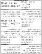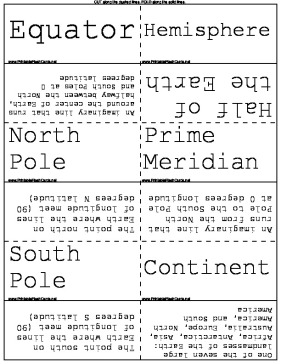
Learn about the degrees and locations on a map or globe with these flash cards
There are 12 flash cards in this set (2 pages to print.)
To use:
1. Print out the cards.
2. Cut along the dashed lines.
3. Fold along the solid lines.

Sample flash cards in this set:


| Questions | Answers |
|---|---|
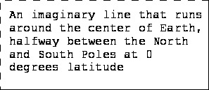
| Equator | An imaginary line that runs around the center of Earth, halfway between the North and South Poles at 0 degrees latitude |
| Hemisphere | Half of the Earth |
| North Pole | The point north on Earth where the lines of longitude meet (90 degrees N latitude) |
| Prime Meridian | An imaginary line that runs from the North Pole to the South Pole at 0 degrees longitude |
| South Pole | The point south on Earth where the lines of longitude meet (90 degrees S latitude) |
| Continent | One of the seven large landmasses of the Earth: Africa, Antarctica, Asia, Australia, Europe, North America, and South America |
| Grid | A pattern of lines that form squares |
| Index | An alphabetical listing of place names on a map and the grid squares in which they are found |
| Degrees | Units of latitude and longitude ( is the symbol for degrees) |
| Lines Of Latitude | Imaginary lines on the Earth that run parallel to the equator |
| Lines Of Longitude | Imaginary lines that run between the North and South Poles |
| Parallel Lines | Lines that are the same distance apart; lines that never meet or cross |